
Oakland Crosstown Freeway
Oakland Crosstown Freeway
Proposed in 1963 as a part of the Pittsburgh Area Transportation Plan, the Oakland Crosstown Freeway was proposed to alleviate the bottlenecks at the Liberty Tunnel, on PA 51, the Fort Pitt Tunnel, and all bridges into the city from the south. The expressway, carrying between 80,000 and 100,000 cars a day, would have started at an interchange with the proposed Saw Mill Run Expressway/South Hills Expressway in Overbrook. From there it would have headed northeast through Knoxville and Mt. Oliver to cross over East Carson Street north of the intersection with Becks Run Road. At East Carson Street, it would have had an interchange with the Mon Valley Expressway/Pittsburgh-McKeesport Expressway before crossing the Monongahela River.
On the northern shore, the expressway would have paralleled Second Avenue in a northerly direction before going over or under the Parkway East. Then it would have skimmed the western end of Schenley Park, behind Phipps Conservatory, before heading into Oakland.
The cityscape of Oakland would have changed as the Oakland Crosstown would have either tunneled through, or been left as a depressed right-of-way as it intersected Forbes Avenue somewhere between the 4500 to 4900 blocks. Afterwards, it would have crossed Fifth Avenue near South Neville Street and Baum Boulevard. The expressway would have then crossed Liberty Avenue, Penn Avenue, and Butler Street before entering Lawrenceville, where it would span the Allegheny River on a new bridge. Once on the north shore of the river, and after intersecting the Allegheny Valley Expressway, the Oakland Crosstown would have headed on a northwesterly direction through Millvale and over Troy Hill Road to link with the East Street Valley Expressway near McKnight Road. Later revisions to this plan had the highway continuing west to intersect the Parkway West near the Greater Pittsburgh International Airport. The expressway would have been six lanes, except at the bridges and near the Parkway, where it would have been eight lanes. Interchanges would have built at the following locations:
.focus()) |
Click on map for a more detailed plan. |
The total cost of the project would be $162 million; however, with the price of the Interstate System increasing, money began to come into short supply at the Department of Highways in the late 1960s. If the Oakland Crosstown Freeway was to be built, an alternative means of funding would be needed. In 1967, a year-long study by Wilbur Smith and Associates of New Haven, Connecticut concluded and the results pointed to building the expressway as a toll road. However, the price would have escalated to $195 million from $162 million cost of building it as a free highway. The difference is that a toll road would require design and construction of ramps, special ramps and approaches and maintenance of the same, plus the cost of retiring the bonds for construction through a bond issue under the toll road plan.
Another variation of the plan would include the crossings of the rivers being the only sections tolled. Section four of the plan, which included the Monongahela River crossing, would have cost almost $39 million itself. The remaining sections of the highway would have been free. The state applied for the expressway to become eligible for Interstate funding.
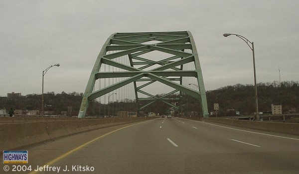
Northbound on the Birmingham Bridge which was built to carry the Oakland Crosstown
Freeway across
the Monongahela River.
The study also concluded that the project could not be financed entirely by toll revenue. "Substantial deficits would accumulate from the Oakland project totaling 166 million dollars" over the next 40 years, according to Wilbur Smith and Associates. The State Highway Commission said the deficit would come from lack of commercial traffic on the expressway.
State highway officials had hoped the study would recommend the expressway to become a toll road so that construction could get underway early. Previously, officials said that it could not be added into plans until after 1972 if it was to be built as a free route. It was hoped that construction could commence sooner under the toll road plan. The State Highway Commission said they did not rule out the highway being built as a toll road and being financed in part by tolls and state revenues to get construction underway. The State Highways Commission, Department of Highways, and the Pittsburgh planning authorities all agreed that the expressway was needed. The study undertaken by Wilbur Smith and Associates only focused on the 11 miles from the South Hills to the North Hills, and not the entire proposed route to the airport.
In March 1968, Allegheny County asked the state for $162 million dollars for expressway construction and another $87 million for arterial highways throughout the county. They and the City of Pittsburgh asked for $174 million for highway construction. If approved, the project would have been included, and slated to begin sometime between July 1973 and June 1975.
In August 1969, all design work on the Oakland Crosstown, or what local planners had dubbed the "missing link" in the proposed network, halted and dropped from the department's six-year construction plan. The decision to stop was made by the State Highways Secretary Robert G. Bartlett, after $150,000 had been paid to Richardson Gordon and Associates, consulting engineers.
Outraged by the news, the City's planning and development director, John T. Mauro, said, "We're going to register a strong protest with the Highways Department." The halt was the 70th ordered by Bartlett on work on proposed Pennsylvania highways for financial reasons since November 1968. Mauro said, "Aside from the roads already programmed for construction, this is probably the most important roadway in Allegheny County -- the missing link." He went on to say, "Without knowing how the Oakland Crosstown will intercept the Saw Mill Run Expressway, we can freely predict that the Saw Mill Run Expressway will be obsolete before it is opened. We're leaving the whole Oakland community hanging in mid air."
Director Mauro said it was imperative that the detailed design be completed as soon as possible so that expansion by the University of Pittsburgh and Carnegie Mellon University could be related to it, since the expressway was proposed to run through Schenley Hollow. He went on to say that the highway could be built in stages, with the 5.3 mile section from Overbrook to Fifth Avenue in Oakland being the most critical. Other developments could not take place until the width of the highway and types of pillars necessary to support air-rights development was known.
He went on to say that the first section of the expressway could have been built from Overbrook to Carson Street at an estimated cost of $25 million. The second from Carson Street to the Parkway would have cost around $49 million dollars, and the third from the Parkway to Fifth Avenue would have cost $21 million.
In April 1972, one last ditch effort to put the Oakland Crosstown on the map was tried by the City Planning Commission. Director Robert J. Paternoster said, "We want to resolve this issue now. Studies by the Southwestern Pennsylvania Regional Planning Commission have always showed a tremendous need." He went on to say that, "What we want to determine is what kind of transportation facility could be built there. The result of this study may be no expressway, or a recommendation for an arterial or lower-grade road." At the Department of Transportation, District Engineer Anthony J. Gaeta said his office was anxious to make the study. He said, "There's no question of the need for this road. The question is the community impact, the reaction of the community." He explained that previous requests from the district office to Harrisburg for authority to conduct corridor studies have been rejected.
Traffic use projections, compiled by the Southwestern Pennsylvania Regional Planning Commission, showed that the Oakland Crosstown corridor would become the most heavily traveled highway by the year 2000. The entire expressway would total 15.4 miles with the interchanges added in, and cost $14.5 million per mile. Gaeta estimated that by the time the highway was built the cost would escalate to about $25 million-a-mile. Unfortunately, it would never come to fruition, as the project was killed by the state in the mid-1970s due to economic reasons.
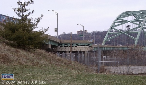
Stub ramps at the southern end of the Birmingham Bridge, a testimony of what was
to
have been built.
Links:
South Hills Expressway (Cancelled)
Pittsburgh-McKeesport Expressway (Cancelled)
Second Avenue Relocation (Cancelled)
East Liberty Expressway (Cancelled)
Birmingham
Bridge - Bruce Cridlebaugh